My research seeks to understand the mechanisms underlying extreme climatic events, with a particular focus on the effects of topography on the atmosphere. The motivation for my work stems from fascination with the scientific principles governing the evolution of weather and climate, and from an urge to care for vulnerable communities and ecosystems.
Current topics
Atmospheric feedback in ocean warming
The North Indian Ocean (NIO), including the Arabian Sea and Bay of Bengal, is one of the warmest regions of the global ocean during the premonsoon months. In May-June 2024, I participated in a research cruise to better understand air-sea interactions over the Bay of Bengal during the monsoon onset. Understanding premonsoon ocean warming and cooling at monsoon onset is crucial for protecting marine ecosystems (e.g., coral reefs, fish populations, coastal communities) and for monsoon forecasting. Investigation of the observations from the Indian peninsula and the Bay shows that land-atmosphere interactions during continental heatwaves lead to a strong inversion (a rapid increase in temperature and dryness with height) over the Bay [Phadtare et al. (submitted)]. This suppresses cloud cover allows more solar radiation to reach the ocean surface, thereby warming the ocean. It leads to a compound heatwave over the region, with both land and ocean experiencing extreme heat.
Dynamics of land-sea breezes in the tropics
In midlatitudes, where the inertial frequency (\(f\)) is greater than the frequency of the diurnal cycle (\(\omega\)), land-sea breezes are in phase with the heating/cooling of the land surface. In the tropics, \(f < \omega \). Therefore, the heating- and land-sea-breeze system can exhibit a phase lag depending on latitude. Furthermore, changes in the boundary-layer stratification (\(N\)) can alter turbulent friction, thereby causing inertial oscillations. Using simple models, I am analyzing what combinations of diurnal forcing and turbulent friction produce the observed land-sea breeze circulations in the tropics. A more ambitious goal is to incorporate the effects of orography into this model, then to understand how the dynamics is affected by climate warming.
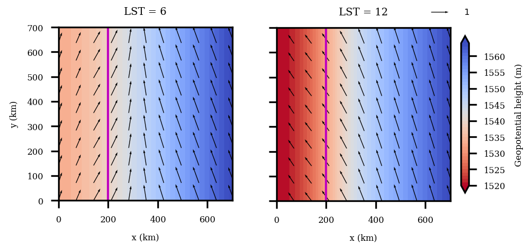
Horizontal flow at 06 and 12 LST mimicking land-sea breeze circulation.
Topographic steering of Convectively Coupled Kelvin Waves (CCKWs)
The Convectively Coupled Kelvin Waves (CCKWs) are eastward propagating tropical atmospheric waves with a period between 3 and 17 days, a wavelength of about 10,000 km, and a speed of about 15 m. These waves are responsible for the large-scale organization of tropical clouds/rainfall and play a significant role in tropical climate dynamics. Previously, CCKWs were studied separately over Africa and the Indian Ocean. We studied the evolution of CCKWs propagating across the two regions. We show that the East African Highlands obstruct the passage of CCKWs and divert a portion of the wave northwards, thereby weakening the wave arriving over the Indian Ocean [Phadtare and Fernando (2025)]. This finding has important implications for understanding the fundamental dynamics of the tropical atmosphere.
Previous topics
Influence of underlying mountains on cyclonic systems
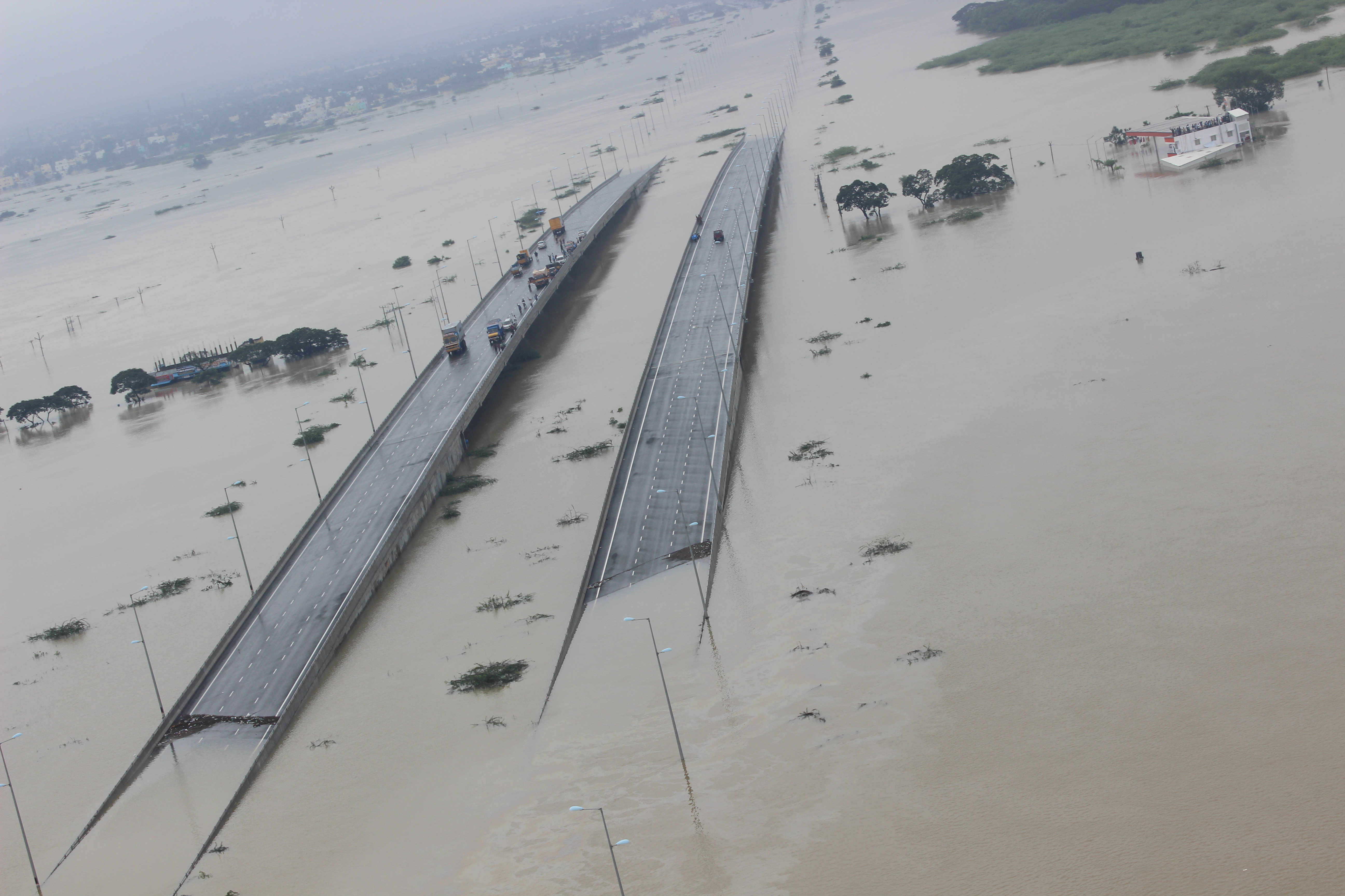
Indian Air Force rescue operation during the 2015 Chennai floods.
The east coast of India is prone to extreme floods during the winter monsoon, e.g., the 2015 South India floods. The influence of the Western Ghats on the west coast rainfall has been known for a very long time. My PhD research proposed, for the first time, the role of the Eastern Ghats in East Coast rainfall. Even though the Eastern Ghats lie about 200 km inland from the coast, the orographic effect is conveyed through the cold pool, a 'thermodynamic mountain'. In a weak background flow, tropical cyclones move westward due to the planetary β effect. Therefore, cyclonic storms that form over the eastern Indian Ocean-Maritime Continent region tend to reach the east coasts of India and Sri Lanka. Some of these storms stall over the coast, causing catastrophic flooding for several days. The goal of this research was to identify the causes of the stagnation of these cyclonic storms, enabling better forecasting of severe flooding events and preventing loss of life. Initial investigations suggest that the weaker storms are blocked by the Eastern Ghats orographic range
[Phadtare (2018) and
Phadtare (2023)].
Modelling Rainfall over the Western Ghats
The Western Ghats are one of the rainiest places on our planet. The low-level monsoon jet from the southwest brings loads of moisture over the west coast of India. The Western Ghats provide a mechanical uplifting mechanism for the advected warm and moist air parcels. Thus, the west coast of India is prone to life-threatening flooding during the summer monsoon months, as evidenced by the Mumbai flood in July 2005 and the Kerala flood in August 2018. My research at the National Centre for Atmospheric Science, University of Leeds, investigated the orographic effects of the Western Ghats on West Coast rainfall and their representation in numerical models. It was concluded that a model resolution of O(1km) is needed to simulate the mean rainfall accumulation over the Western Ghats. However, even at this high resolution, models overestimate rainfall (by 50-100%) over the orography, especially during the phases of weak winds/offshore rainfall. This error stems from an anomalously weak orographic blocking effect in models.
[Phadtare et al., (2022) and
Phadtare et al., (2023)].
Organization and Life Cycle of Deep Cloud Systems in the Indian Summer Monsoon
Representation of clouds in the general circulation models is one of the biggest challenges for the atmospheric science community. Simultaneously resolving the full spectrum of the involved scales is computationally infeasible. Recent simulations from cloud-resolving models (CRMs) have shown promising results. However, the problem is not just limited to computational power; uncertainties plague our understanding of the physical processes in clouds. Therefore, there is a need to study real-world cloud processes and to set benchmarks for CRMs. High-resolution data from geostationary satellites is helpful for this purpose. During my PhD, I studied the life cycle of deep clouds of the Indian summer monsoon using INSAT-series satellite data. Special focus was on studying the cloud organization with and without the synoptic-scale forcing. An automated cloud tracking code was written for this purpose. Some of the questions addressed in this study are the following: Is there a systematic organization of MCSs within the monsoon depressions? In what aspects do the MCSs differ when the synoptic-scale forcing is strong and weak? [Phadtare and Bhat (2019)]
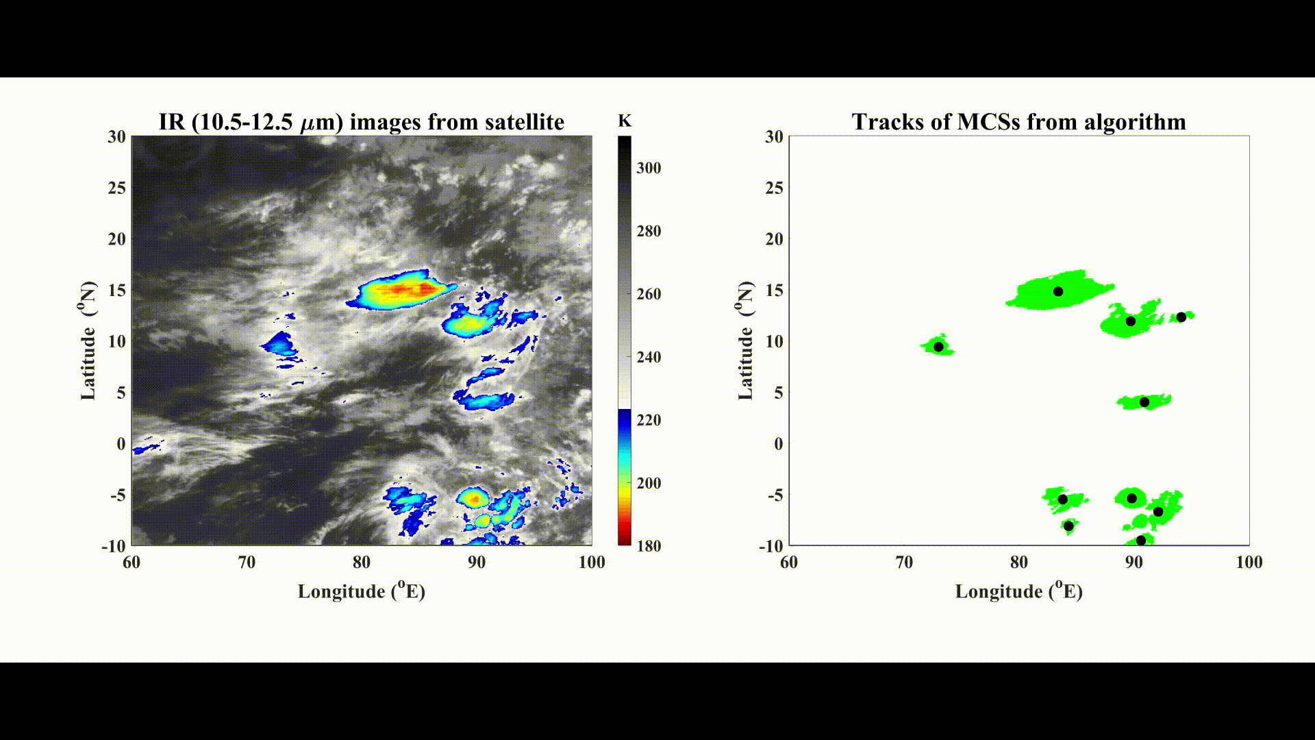
Automated cloud tracking in the Kalpana-1 satellite images.